Guest post: Jagadish Vallarampara from Fugro
Everyone knows tropical cyclones are dangerous. For example, in 1999, a supercyclone struck the Bay of Bengal in the Indian ocean, killing approximately 10,000 people and leaving an estimated 1.5 million people homeless. Early warning systems are vital for saving lives and safeguarding livelihoods, which is where our metocean data can step in.
My first Fugro metocean buoy deployment and deepwater mooring experience was along the east coast of India in 2004, as part of a measurement campaign using Fugro’s SEAWATCH weather buoys along India’s east and west coasts. These buoys are now part of India’s National Data Buoy Programme, monitoring coastal metocean conditions and providing valuable metocean data to avoid any repetition of the 1999 supercyclone tragedy.
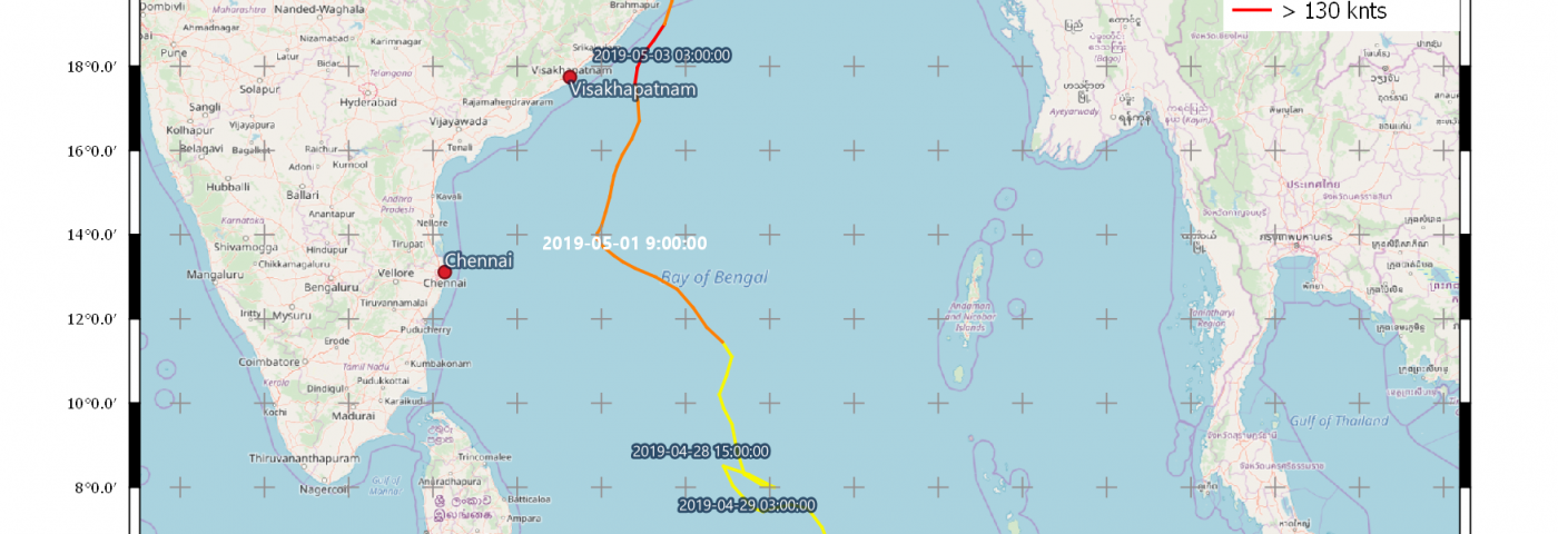
Jump to 24 April 2019, when I was monitoring real-time weather data around the Indian Ocean from my office in Wallingford, UK, and I noticed a cyclone forming, though not fitting the pattern for that time of year. I later understood that I had been watching Cyclone Fani brew before starting its 11-day journey towards Odisha. Cyclone Fani was unusual in that it occurred before the monsoon season and moved north away from the equator. The cyclone’s initial path was towards Tamil Nadu region but it eventually hit one of the poorer and more densely populated states in Odisha; wrongly mapping the cyclone would have led to resources being deployed 1300 km south of its final landfall, with potentially colossal humanitarian and financial implications.
Tracking the cyclone allowed us to correctly map its path and the government authorities in Odisha did not hesitate when our metocean data revealed that a killer cyclone was on its way. The authorities activated all available communication channels, sending 2.6 million text messages and deploying 43,000 volunteers and nearly 1000 emergency workers. Television warnings were broadcast and coastal sirens activated, whilst public address systems blared looped alerts in the local language: “A cyclone is coming. Get to the shelters”. Behind the scenes, a meticulous evacuation plan enabled the safe evacuation of 1.2 million people.
Over the years, our technical innovations have allowed us to produce weather models using satellite and metocean buoy data in coastal areas where depressions, cyclones and tsunamis occur, proving that “data with a purpose” can save lives. Being part of this initiative has been an incredible experience, where I’ve seen for myself how technology such as our SEAWATCH wind lidar buoys deployed strategically at sea can truly be the first line of alert: something for all countries at risk of coastal exposure to consider.
For more information, please visit us at Oceanology, Stand D100 and come and talk to us about any projects you may be considering. Register to attend for free.
Jagadish Vallarampara, Principal Project Manager, Metocean
j.vallarampara@fugro.com


